Mt. Hebo Area
Seasons
Checklists
Location
Mt. Hebo is a 3200 ft elevation area on the Siuslaw National Forest about 27 miles from Tillamook.
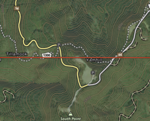
To reach Mt. Hebo from the intersection of Highway 101 and Highway 22 in Hebo, turn onto Highway 22 (southbound), travel 0.2 miles to Forest Road 14 (two lane paved) on the left. Turn left and travel on Forest Road 14. As you ascend Forest Road 14 from Hebo there are several possible birding stops. At about 4.6 miles there is the signed access road for Hebo Lake (45.230684, -123.796657) on the right. The lake is 0.1 mile down this road. Continuing on Forest Road 14 for another 1.1 miles is the trailhead for the Pioneer-Indian Trail #1300 on the right. Continuing for another 2.1 miles on Forest Road 14 brings you to the first of the open ridge top areas in Yamhill Co. This area is Mt. Hebo (Yamhill Co.) (45.213106, -123.756417). This is the restored site of an Air Force NORAD radar station that operated until 1979.
From this area, continue along Forest Road 14 (now single-lane gravel) for 1.0 miles to the area of Mt. Hebo (Tillamook Co.) (45.223407, -123.743197). Continue along Forest Road 14 for 1.0 miles to a spur road and informal trailhead on the left. Park here and walk up the abandoned road/trail to the east for about 0.2 mile to Mt. Hebo – east summit (45.221093, -123.724812)
Directions
Habitat and Birds
The Mt. Hebo area is located at a relatively high elevation in the coast range. The entire area is under-birded.
County listers note that a portion of the area is in Yamhill County.
The fire history and elevation make the habitats and birds somewhat distinct. The higher areas are characterized by open grassland meadows, areas of low brushy vegetation, and forest edges. The open areas are remnants of a series of large historic fires. The forest here is largely Douglas Fir. The higher elevation open areas are the most unique habitats. The meadow areas are Oregon Silverspot butterfly restoration sites.
Birding at stops along the road, walking the open meadow areas, and walking segments of the Pioneer-Indian Trail can be good. Species include Wilson’s, Hermit, Orange-crowned, Black-throated Gray, and (with luck) MacGillivray’s Warblers, Band-tailed Pigeon, Northern Pygmy-owl, Canada Jay, Olive-sided Flycatcher, Evening Grosbeak, Red Crossbill, and Townsend’s Solitaire (spring and fall). Flocks of American Pipits are sometimes found using the open meadow areas in September. Chipping Sparrow flocks have been seen in summer.
As you ascend Forest Road 14 from Hebo. Stops anywhere along the road and at Hebo Lake and Pioneer-Indian Trail #1300 trailhead can have good birding. Watch and listen for flocks as you drive. Varied Thrush is commonly seen foraging on and along the road, especially in the early morning. Stops have typical coast range forest birds with good woodpecker populations, Northern Pygmy-owl, Hammond’s and Pacific Slope Flycatchers.
eBird Checklists:
eBird Hotspot checklist for Mt. Hebo (Yamhill Co.)
eBird Hotspot checklist for Mt. Hebo (Tillamook Co.)
eBird Hotspot checklist for Hebo Lake
Discussion