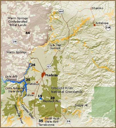
Crooked River National Grasslands
Seasons
Checklists
Location
This large area is located mostly east of Hwy 97 and extends from north of Madras to Grizzly Butte on the south side. There are multiple access points (some described below). It is suggested that you simply get a grassland map and go exploring. CAUTION: Deep ruts and rough, dirt roads are the norm, not the exception so be careful. Below, Below are some areas that can be accessed by most vehicles and have access roads that are passenger car friendly. SW King Lane and Osborne Springs – 44.487985, -121.165921 – East of the town of Culver, you will find Haystack Reservoir. From the SW corner of the reservoir, take King Lane east for 2 miles and you will be back at Hwy 97. Osborne Springs is an old homestead on this road. Good for Gray FC, BG Gnatcatcher, migrant passerines in the spring and all the other sage species. East of Haystack (Jasper Road) – From Haystack, continue east to SE Laurel Lane. Take this road slowly and bird along the way. Turn left on Jasper Road and you will have about 10 miles of open grasslands in front of you. Jasper Road is generally good for passenger cars but there are many opportunities to take side roads that may or may not require a more rugged vehicle. Madras to Grizzly – From the corner of 5th and J St. in Madras, turn east. On J St., travel 1.0 mile to a round-a-bout. Turn south on Grizzly Road. On your right will be the Madras Sewer Ponds (541-948-6970). Continue on this road for 8.7 miles. Stop in different habitat areas and search for sage and juniper birds. At 8.7 miles, the road will fork (44.541606, -121.018983). The right fork will take you to Rimrock Springs and, eventually back to Hwy 26. The left fork will take you farther out into the grasslands and to the ghost community of Grizzly (only a ranch house remains). Should you take the right fork, the road will go for 5 miles to Grizzly. Turn right at Grizzly and follow the road south until it hits pavement. Take the pavement west to Hwy 26.
Amenities: Birding! Horse & car camping. Campground has a restroom. This spot deserves more attention from birders. A nice loop is to start at Peter Ogden Wayside, continue through Hawk Alley, stop at Haystack Reservoir, continue to Cyrus Springs and end your day of birding with Rimrock Springs Wildlife Management Area.
Crooked River National Grasslands Map
(This area is in the Utopia Christmas Bird Count Circle)
DirectionsHabitat and Birds
The flat “grasslands” is mostly Juniper forest and sagebrush lands. On the slopes of Gray Butte there are some interesting springs where Lazuli Buntings can be found and migrant songbirds. The flat areas have breeding Lark, Sagebrush (rare), Vesper and Brewer’s Sparrows. Sage Thrashers are common and you can see Prairie Falcons, Golden Eagles, Gray Flycatchers, and Loggerhead Shrikes in the summer. In the winter look for Northern Shrike and winter raptors. Other Key Species: American Goldfinch, Ash-throated Flycatcher, Town- send’s Solitaire, Northern Shrike, Loggerhead Shrike, Horned Lark, and Western Meadowlark. Exceptional Species: Long-eared Owl, Blue-gray Gnatcatcher
Discussion