Ollalie Meadows
Home » Birding Locations » Marion County » Hwy 20 To The Cascades
Seasons
Checklists
Location
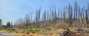 Much of the town of Detroit and the surrounding forest was destroyed by the 2020 wildfires, and as of September, 2022 much of the area is still closed, including access to Olallie Meadows from Detroit. The current closure extends until July 31, 2023. Check the US Forest Service website for updates and current status after that date. The only access to the site at this time is from the north, through Clackamas county, via US 26, FR 42 and FR 4200.
When the area is open, there are two ways to reach Olallie Meadows. From SR 22 in Detroit, follow FR 46 north for 23 mi, right on FR 4690 for 8 mi, then R on FR 4220 for 6.5 mi to the campground. From Estacada in Clackamas Co go south on SR 224, FR 42 and FR 4200 to reach the area.
DirectionsHabitat and Birds
Open June thru September, Olialie Meadows is a high-elevation wet meadow//bog area, supporting nesting birds such as Sandhill Crane, Solitary Sandpiper and WIllow Flycatcher. Black-backed and American Three-toed Woodpecker, Cassin’s Finch, Chipping Sparrow, Western Tanager, Black-headed Grosbeak, and Hermit, Townsend’s and Yellow-rumped Warbler can be found in the wooded areas.
Discussion